3.3 Spatial development and the transport system
In the context of the transport system, VASAB has engaged in two fields: regional development in transnational transport corridors, and promotion of maritime transport through spatial development measures.
3.3.1 Transnational transport corridors
VASAB projects
This line of projects was initiated with the aim to get a closer dialogue between institutions responsible for transport infrastructure resp. spatial development, between local & regional and national & international actors.
Through this, it was hoped, regional development impacts would be given more consideration when preparing infrastructure development plans. This, in turn, would help regions to draw higher benefits from infrastructure investments, and to improve the benefit-cost ratio of such investments.
Two trans-European corridors were selected as prototypes: corridor no.1 (Via Baltica Spatial Development Zone VBSD) on its section Tampere - Helsinki - Tallinn - Riga - Panevezys - Kaunas - Marijampole - Warsaw; and no. 2 (Berlin - Warsaw - Minsk - Moscow) on its section in Belarus (Brest - Orsha).
These pilot projects focused on the participation of local and regional actors, on the best use of improved accessibility for regional development and on the consideration of regional development interests in planning for strategic transport infrastructure projects.
VASAB project:
Via Baltica Spatial Development Zone (VBSDZ)
This co-operation project was started by VASAB soon after adoption of the VASAB2010 report as THTR project (Tampere- Helsinki- Tallinn - Riga). It was later continued with extension through Lithuania towards Poland and Berlin in the framework of InterregIIC and Phare.
Main partners of this extended project are regional planning bodies in Finland, in the Baltic States, in Poland and in Berlin/ Brandenburg (Germany). National Ministries responsible for Spatial Planning of these countries are also involved.
The project seeks to facilitate infrastructure investment in the corridor through a dialogue with responsible institutions. Infrastructure plans are linked to future spatial settlement structures and to environmental impact analysis (EIA). This shall be the basis for sustainable development. Securing and enhancing the values of cultural heritage are an important aspect.
Trend scenarios, visions and strategies were developed with the goal to make the corridor zone an internationally competitive, cooperative and innovative region.
Guidelines for Spatial Planning have been prepared to demonstrate ways how to put sustainable development in practise.
The project has contributed to enhanced use of GIS for planning purposes.
Particular attention was paid to sustainable transport as regards internal urban structures as well as fast inter-city railways to connect region's capitals, and to the protection and development of natural and cultural heritage, including green networks. A common environmental monitoring system has been proposed.
Local and regional actors were actively involved. Cross-sector co-operation and dialogue between local/ regional and national/ transnational decision makers were initiated.
|
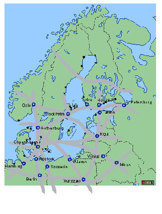
Transnational transport corridors studied in various BSR Interreg II C projects
|
|
Brest - Minsk - Orsha Development Zone
The project area is the Belorussian section of the pan-European corridor from Berlin to Moscow. Common work also started soon after the Tallinn conference.
The project aim was to identify ways how this central development axis of Belarus can best benefit from envisaged transport infrastructure improvements.
For this purpose, a process was initiated to involve representatives from national sector institutions as well as local administrations and enterprises. This process led to the identification of potential actions which promote economic and social welfare through sustainable spatial development and promotion of the values of existing natural and cultural heritage.
This process approach, jointly developed by Belorussian and German experts, was seen in its function to promote participation, decentralisation and subsidiarity. The detailed elaboration of proposed priority actions could not be started due to funding limitations.
This VASAB approach has demonstrated benefits in various aspects:
It strengthened the understanding, among local authorities, on their potential to benefit from and to influence major strategic investments;
It highlighted the need for supporting local actors in their dialogue with national and transnational bodies planning for strategic investments.
It influenced strategic plans at national levels.
It made the concept of sustainable development operational.
Similar InterregIIC projects concerning transport corridors
The VASAB projects gave rise to a number of corridor projects within InterregIIC:
|
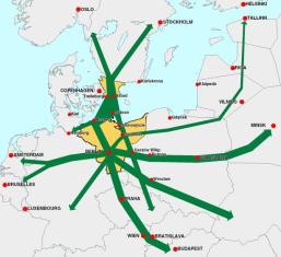
The TransLogis Area
|
|
InterregIIC project:
TransLogis
TransLogis deals with impacts of transport development on the project area (Berlin-Brandenburg, Mecklenburg-Vorpommern, north-western Poland and Skåne/ southern Sweden).
The project aims at an enhanced role of environment friendly transport modes. It considers the following international road and railway corridors:
- Berlin-Szczecin-Gdańsk
- Berlin-Gorzow-Poznan-Minsk
- Berlin-Cottbus-Cracow and Cottbus-Prague-Bratislava-Budapest
- Berlin-Rostock-Trelleborg
- Berlin-Mukran-Ystad/ Trelleborg
- Skåne/ Ystad-Swinoujcie/ Szczecin-Gorzow-Prague
- Berlin as traffic node to the West and South
Main project activities refer to:
- analysis of transport demand trends
- development of competitive logistical solutions to optimise transport chains,
- recommendations for harmonisation of spatial planning to create synergy for economic development and environmental protection
- recommendations for further development of transeuropean transport networks, including supporting infrastructure
- identification of further planning needs.
|
The E18 project area
|
|
Corridor projects
Conclusions
The regional corridor project approach has been useful for local development in transnational networks. Various InterregIIC projects have continued this line of action.
A logical next step is to discuss future transnational infrastructure network concepts such as TEN/ TINA, identifying priorities from spatial development point of view, adding to the infrastructure planning methodology, and promoting the use of harmonised forecasts.
|
InterregIIC project:
E18
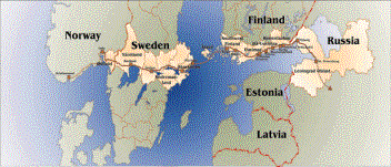
Spatial Planning Network for Urban and Regional Development European Road E18
This link connects the capitals of Finland, Sweden and Norway and the City of St. Petersburg. It is part of the Trans European Network (TEN). The project consists of three parts: E18 Information Network, E18 Transport Corridor development, E18 Urban and Regional Planning issues.
InterregIIC project:
BALTICOM
Transport Communication and Regional Development
BALTICOM deals with the interface of transport and spatial planning. It seeks to improve maritime transport co-operation with focus on new information and communication technologies, multi-modal centres and port-hinterland connections. It analyses spatial effects of these improvement through regional case studies in southern Finland, northern Germany, Russia - St. Petersburg, Gdańsk and Klaipeda.
Project partners are spread over the BSR, with local, regional and national authorities in Finland, Sweden, Russia, Poland and Germany, as well as private companies running concrete transport chains.
InterregIIC project:
SEBtrans
This project deals with 3 corridors:
- The east-west axis: UK - Denmark - south-east Sweden- Poland - Kaliningrad/ Lithuania/ Latvia.
- The northwest-southeast axis: (Oslo-) Gothenburg - south-east Sweden - Poland - south-east Europe and the
- The north-south axis Mälardalen/ Bergslagen - south-east Sweden-Poland.
It is based on an earlier Swedish-Polish initiative which initiated successfully the new ferry link Gdańsk - Karlskrona.
The objective of the project is to promote transport infrastructure development with a focus on sustainable solutions.
It contains the following main activities:
Part A: Transport of goods in the southern Baltic - options for the future
- Establish present and future transport volumes and patterns
- Assess and demonstrate the potential for intermodal transport
- Study the role of short-sea shipping
- Identify environmental consequences of increased transport volumes in the South East Baltic.
Part B: TEM/TER Development Zone - development options
- Identify development problems in the Zone.
- Describe regional consequences of different development scenarios.
- Define a common strategy of balanced distribution of economic activities and human resources in the TEM/TER development zone.
- Develop innovative methods and forms for consultations between different levels of expertise and politicians for a co-ordination between different sector measures.
- Recommend future infrastructure improvements within the area of influence.
Part C: Forecast of passenger traffic in the South East Baltic on existing and potential new ferry lines
Part D: Regional impact study of the south East Baltic
- Describe the regional impact of increased transport volumes at local and regional levels.
- Detect economic development barriers.
3.3.2 Promotion of maritime transport through spatial planning
VASAB Task (Stockholm Ministerial Conference):
Cooperate with Ministers of Transport towards a programme on maritime transport in the BSR
Co-operation with Ministries of Transport on enhancing
Maritime Transport
Conclusions
The MATROS project has contributed to a dialogue between maritime transport experts and urban and regional development planners, with new insights into their mutual dependency.
There is a need to involve ministries and national authorities dealing with environment issues and safety/risks related to sea transport and the handling of hazardous cargo.
Practical concepts how sectors can cooperate to promote maritime transport in a sustainable way shall be further explored.
|
The Baltic Sea is a sea of intensive maritime transport. Major parts of trade and travelling between BSR countries are arranged on ships. Regular liners maintain links with North Sea ports and thus with other parts of the world.
This maritime transport relieves the land-based transport infrastructure and hence the environment.
A trend to concentrate ferry, container and conventional traffic flows to a few harbours leads to growing pressure on harbour cities and on their hinterland infrastructure. It also contributes to the decline of a larger number of small harbours - coupled with declining fishery - forcing them to seek new bases of economic development (one of which is boat tourism tackled by the SuPortNet project described above).
VASAB project:
MATROS
These issues are the object of a project initiated by VASAB on the "Development of the maritime transportation system in the BSR from a spatial development perspective (MATROS)"
MATROS provides an overall perspective of maritime transport development in the BSR. The project systematically analyses how spatial planning can contribute to the development of this environment friendly mode of transport.
The ambition is to simultaneously deal with spatial and transport planning issues and to provide a planning methodology for sustainable maritime transportation and port hinterland connections.
The Swedish lead partner has arranged for a joint project leadership by national authorities responsible for spatial development (through the Swedish Board of Housing, Building and Planning) respectively for maritime transport (through the Swedish Institute for Transport and Communication). Other BSR countries participate through their national spatial planning ministries. This is probably the first co-operation of such institutions.
The project has established a common information base on current and future maritime transport flows. It has contributed to a better mutual understanding between maritime transport sector and spatial planning institutions.